Graphical and Cartographic skills revision Flashcards
(18 cards)
Type of graph that can be used to show multiple sets of data, for example traffic counts for the same place at different times
Line graph
This can be used to show flow of migrants or imports between places
Desire Line or Flow Line Map
This is a chart that is good for showing data that adds up to 100% in divided parts
Pie chart
A way of presenting data which incorporates relevant pictures
Pictogram
A type of map that is shaded according to a prearranged key, each shading representing a range of values
Choropleth maps
Circles drawn on a map to show the size of the values being represented
Proportional circles
This can be used to plot two types of data against each other - often a line of best fit can be drawn
Scatter diagram
Used to show a range of a set of data. It shows whether the data tends to be grouped together or is spread out
Dispersion graph
A diagram that uses straight line to show movement or a connection between two places
Star or Radial Diagram
A diagram that can be used to show changes in vegetation types over a particular distance
Kite diagram
What is the interquartile range and why do we use it?
It shows us how spread out data is. It shows us the spread of the middle 50% of the data between the upper quartile and the lower quartile
What is this map symbol?
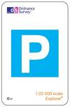
Parking - try and learn some other map symbols as part of your revision
Give the 6 figure grid reference for the telephone in Thornhill

196835
Name three ways to show height on a map
Contour lines
Spot heights
Shaded relief maps (darker colours showing higher grounds)
What are some advantages of GIS?
- A lot of information can be seen on one map
- Information can be linked together easily to form patterns that can be analysed
- It is of great benefit to many public services such as the police and utilities
What are some of the disadvantages of GIS?
- The information can become too difficult to see if too much is put onto one map
- A computer or other ICT equipment is needed as the maps are digital
- The equipment is expensive to buy and keep up to date
- A certain amount of training is needed to use the more spohisticated systems
What is the difference between a Vertical and an Oblique photo?
Vertical is directly down. Oblique takes the picture at an angle
What is the 6 figure grid reference for point X?

813614
