VFR Aeronautical Charts - ATP Flight School Flashcards
(32 cards)
ATPFlightSchool.com
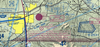
Provide as much information as you can about the Triangle North Executive Airport based on this image.

- Airport code: LHZ
- No control tower
- Weather info (AWOS-3) on 118.325 MHz
- Field elevation: 368’ MSL
- Lighting available with limitations (check A/FD for more info)
- Longest runway: 5,500’
- CTAF: 123.0 MHz
- Right traffic to Runway 5
- 1 paved runway oriented NW-SE
- Has a rotating beacon and fuel/services available
- Has parachute jump and glider activity.
- In Class G airspace, with Class E above beginning at 700’ AGL. (Likely has instrument approaches.)
ATPFlightSchool.com
Provide as much information as you can about the Palm Springs International Airport based on this image.

- Airport code: PSP
- Control tower frequency: 119.7 MHz
- Tower operates part time. 119.7 MHz is the CTAF when the tower is closed.
- ATIS frequency: 118.25 MHz
- Field elevation: 476’
- Lighting available w/ limitations (check A/FD)
- Longest runway: 10,000’
- Right traffic to Runways 31L, 31R
- 2 paved runways, parallel, oriented NW-SE
- Has a rotating beacon
- In Class D airspace with TRSA service
ATPFlightSchool.com
Provide as much information as you can about Banning Airport based on this image.

- Airport code: BNG
- No control tower
- Weather info (AWOS-3) on 134.625 MHz
- Field elevation: 2,222’ MSL
- Lighting available with limitations (check A/FD for more info)
- Longest runway: 4,900’
- CTAF: 122.8 MHz
- Right traffic to Runway 26
- 1 paved runway oriented E-W
- Has a rotating beacon and fuel/services available
- In Class G airspace, with Class E above beginning at 1,200’ AGL
- Is a reporting point for a nearby approach control
ATPFlightSchool.com
Provide as much information as you can about Los Angeles International Airport based on this image.

- Airport code: LAX
- Control tower, 2 frequencies: 120.95 MHz and 133.9 MHz
- ATIS frequency: 133.8 MHz
- Field elevation: 128’ MSL
- Lighting active sunset to sunrise
- Longest runway: 12,100’
- 4 paved runways, parallel (2 pairs of 2), oriented WSW-ENE
- Has a rotating beacon
- In Class B airspace
- No special VFR operations allowed
- UNICOM frequency 122.95
- Los Angeles VORTAC located on the field
ATPFlightSchool.com
Provide as much information as you can about Ocotillo Airport based on this image.

- Airport code: L90
- No control tower
- No automated weather available
- Field elevation: 160’ MSL
- No lighting
- Longest runway: 4,200’
- CTAF: 122.9 MHz
- Right traffict to Runways 9 and 31
- No paved runways
- No fuel or services available
- In Class G airspace
- Lies under special use airspace, either an MOA or an alert area (it’s in fact an MOA)
ATPFlightSchool.com
Provide as much information as you can about the Julian navaid based on this image.

- Navaid is a VORTAC.
- Navaid frequency is 114.0 MHz.
- Morse code identifier is .— .-.. ..
- HIWAS weather info broadcast over VOR frequency.
- Pilot can contact the San Diego FSS on 123.65 (duplex communication)
- Magnetic variation is about 10-15 degrees east.
- TACAN channel is 87.
ATPFlightSchool.com
Provide as much information as you can about Thief River Falls Regional Airport based on this image.

- Airport code: TVF
- No control tower
- Weather info (AWOS-3) on 108.4 MHz, the VOR frequency (listen on NAV radio)
- Field elevation: 1,119’ MSL
- Lighting available with limitations (check A/FD for more info)
- Longest runway: 6,500’
- CTAF: 122.8 MHz
- 2 paved runways, longer one NW-SE, shorter crosswind runway NE-SW
- Has a rotating beacon and fuel/services available
- In Class E airspace
- VOR located on the field
ATPFlightSchool.com
Provide as much information as you can about the Thief River Falls navaid based on this image.

- Navaid is a VOR/DME.
- Navaid frequency is 108.4 MHz.
- Morse code identifier is - …- ..-.
- Located on the field at Thief River Falls Regional Airport.
- AWOS information for the airport broadcast over the VOR.
- Pilot can contact the Princeton FSS by transmitting on 122.1 MHz or 123.6 MHz, and receiving on 108.4 MHz.
- DME channel is 21.
ATPFlightSchool.com
Provide as much information as you can about Alton Bay airport based on this image.

- It’s a seaplane base.
- Airport code: B18
- No control tower or automated weather information.
- Field elevation: 504’ MSL
- Longest waterway: 2,600’
- CTAF: 122.8 MHz
- No fuel/services available.
- In Class G airspace, with Class E above beginning at 1,200’ AGL
Fun fact, though not something you can tell from this image: in the winter, Alton Bay freezes over and becomes the only FAA-certified ice runway in the 48 contiguous states.

ATPFlightSchool.com
What is the significance of the blue castellated line running north-south through this image?

It marks the boundary of the Washington DC Special Flight Rules Area (SFRA), an 30 NM radius area around the Washington VOR in which special rules apply. For example, all traffic, even VFR, has to have a Mode C transponder, squawk a discrete transponder code, and be in 2-way radio contact with ATC.
ATPFlightSchool.com
Why is the Shenandoah National Park charted on this VFR sectional?

Pilots are requested to remain at least 2,000’ AGL above national parks, wildlife refuges, etc.
ATPFlightSchool.com
Provide as much information as you can about Front Royal-Warren County Airport based on this image.

- Airport code: FRR
- No control tower
- Weather info (AWOS-3) on 121.85 MHz
- Field elevation: 704’ MSL
- Lighting available with limitations (check A/FD for more info)
- Longest runway: 3,000’
- CTAF: 123.0 MHz
- Right traffic in certain cases (check A/FD for more info)
- The A/FD states that gyrocopters, ultralights, and gliders shall make right traffic.
- 1 paved runway oriented E-W
- Has a rotating beacon and fuel/services available.
- Glider activity present.
- In Class G airspace, with Class E above beginning at 700’ AGL. (Likely has instrument approaches.)
ATPFlightSchool.com
What is the purpose of this special use airspace? What procedures should non-participating traffic use if they want to enter it?

This is a military operations area. It typically contains military flight training activities such as air combat tactics, air intercepts, aerobatics, formation training, and low-altitude tactics. ATC will generally reroute IFR traffic around active MOAs. VFR traffic is not legally restricted from entering active MOAs, but they must exercise extreme caution when doing so due to the increased risk of mid-air collisions. Pilots are strongly advised to contact the controlling agency for traffic advisories.
ATPFlightSchool.com
What is the significance of the blue line running east-west across the MOA?

It is a Victor airway (V128 to be specific), one of the “highways in the sky” that connects VORs. Victor airways form the basis of IFR route planning, but they can also be used by VFR traffic (hemispheric altitude rules keep VFR and IFR traffic separate). The airway is made up of Class E airspace from 1,200’ AGL up to 18,000’ MSL. The “185” in the box indicates that this segment of V128 is 185 nautical miles long.
ATPFlightSchool.com
What is the significance of the gray lines running mostly north-south through the MOA?

They are military training routes (MTRs), used by military aircraft to practice low-level tactical flying. Military aircraft on MTRs are exempt from the 250-knot “speed limit” below 10,000 feet. In this image, IR720 and IR760 are both flown under IFR with segments above 1,500’ AGL. VR43 is flown under VFR with a segment above 1,500’ AGL. VR1754 is flown under VFR with no segment above 1,500’ AGL (as indicated by the 4-digit number). Pilots should contact a nearby FSS to determine whether the routes are active, and use extreme vigilance when crossing an active MTR.
ATPFlightSchool.com
Imagine that you started on the ground at Portland-Troutdale Airport and then climbed vertically to space. List the airspace you would travel through.

- Surface to 1,700’ MSL: Class D
- 1,700’ MSL to 4,000’ MSL: Class C
- 4,000’ MSL to 18,000’ MSL: Class E
- 18,000’ MSL to FL600: Class A
- Above FL600: Class E
(Note that even though the Class D airspace is marked up to 2,500’ MSL, the more restrictive Class C beginning at 1,700’ MSL takes precedence.)
ATPFlightSchool.com
What is the significance of the blue “87” in this image? (Bonus: Why is it that particular number?)

It is a Maximum Elevation Figure, indicating the height of the highest terrain or obstacle within this quadrangle of the chart. “87” represents an altitude of 8,700’ MSL. It was obtained as follows:
- Find the highest terrain or obstacle in the quadrangle - in this case, Mt. St. Helens at 8,365’ MSL.
- Add 100 feet to allow for error in the altitude measurement.
- Since this is a terrain elevation, add 200 feet in case there’s an uncharted obstacle on top.
- Round up to the nearest 100 feet.
ATPFlightSchool.com
What sort of activity taks place just southwest of McGregor, Texas?

Space launch activity. (It’s the SpaceX rocket development facility.)
ATPFlightSchool.com
Imagine that you started at the magenta symbol southwest of McGregor and traveled straight up. What types of airspace would you travel through?

- Surface to 700’ AGL: Class G
- 700’ AGL to 18,000’ MSL: Class E
- 18,000’ MSL to FL600: Class A
- Above FL600: Class E
ATPFlightSchool.com
Provide as much information as you can about the McGregor Executive Airport based on this image.

- Airport code: PWG
- No control tower
- Weather info (AWOS-3) on 135.525 MHz
- Field elevation: 592’ MSL
- Lighting available with limitations (check A/FD for more info)
- Longest runway: 5,500’
- CTAF: 122.8 MHz
- 2 paved runways: longer one N-S, shorter one NE-SW
- Has a rotating beacon and fuel/services available.
- In Class G airspace, with Class E above beginning at 700’ AGL
ATPFlightSchool.com
What is the altitude (AGL and MSL) of the highest obstacle in this image?

2,535’ MSL, 1,739’ AGL (single tower with high-intensity strobes).
ATPFlightSchool.com
Provide as much information as you can about Hayward Executive Airport based on this image.

- Airport code: HWD
- Control tower frequency: 120.2 MHz
- Tower is open part-time. 120.2 MHz is the CTAF when tower is closed.
- ATIS frequency: 126.7 MHz
- Field elevation: 52’ MSL
- Lighting available with limitations (check A/FD for more info)
- Longest runway: 5,700’
- Right traffic to Runways 10R, 28R
- 2 parallel paved runways oriented NW-SE
- Has a rotating beacon.
- UNICOM frequency: 122.95 MHz
ATPFlightSchool.com
Why do the Mid-Span San Mateo Bridge and Lake Chabot visual reporting points have 5-letter codes (VPMID and VPCBT, respectively)?

So that you can enter them as waypoints in the GPS. They have 5-letter codes just like IFR intersections/waypoints, but the “VP” indicates that they are VFR waypoints. They are not intended to be pronounceable like IFR intersection names, and they aren’t used in communication with ATC.
ATPFlightSchool.com
Imagine that you started on the ground at Hayward Executive Airport (HWD) and then climbed vertically to space. List the airspace you would travel through.

- Surface up to but not including 1,500’ MSL: Class D
- 1,500’ MSL to 3,000’ MSL: Class C
- 3,000’ MSL to 10,000’ MSL: Class B
- 10,000’ MSL to 18,000’ MSL: Class E
- 18,000’ MSL to FL600: Class A
- Above FL600: Class E