Water on the Land Flashcards Preview

Geography > Water on the Land > Flashcards

Flashcards in Water on the Land Deck (143)
Loading flashcards...
1
Q

Where does a river start at?

A

Source

2
Q

What is the area drained by a river?

A

Drainage basin

3
Q

What is the end of a river?

A

Mouth

4
Q

Where does the river flow into?

A

Sea or lake

5
Q

Where does a small river join a larger one?

A

Confluence

6
Q

What does a river flow in?

A

A channel

7
Q

What is a stream or small river that flows into a bigger one?

A

Tributary

8
Q

What is the boundary between two river basins?

A

watershed

9
Q

What is the casestudy for the changes in a river from its source to mouth?

A

River Tees, Pennines, North East of England, Flows east to North Sea

10
Q

What is the River Tees’ source in?

A

Marshland

11
Q

What is found in its upper course?

A
  • Moor land - sheep grazing
  • V shaped valleys
  • Reservoirs
  • Forestry
  • Eroded rocks
  • Flood plains
  • Pasteur - cattle grazing
  • Waterfall
12
Q

What waterfall is found in the River Tee’s upper course?

A

High Force - tallest in England

Two rock types are:

  • Whinstone - darker, rougher, harder
  • Sandstone - lighter, smoother, softer

Gorge created below waterfall

13
Q

What features are found in the middle course of the River Tees?

A
  • smaller fragments, more rounded in bedload
  • arable farming
  • meanders
  • Yarm - a town inside a meander
14
Q

What features are found in the lower course of the River Tees?

A
  • Heavy industry - iron and steel works
  • Estuary mud
  • Coal quay
15
Q

Fill in this table about the long profile of a river.

A
16
Q

What is a river’s purpose?

A

To transfer water from source to mouth. As it does that it will erode, transport and deposit.

17
Q

What is erosion?

A

The wearing away of rocks

18
Q

What are the processes of erosion?

A
  • Hydraulic action - the power of the water wearing away the bed and banks
  • Abrasion - load wearing against the bed and banks (sand papering)
  • Corrosion - some minerals in some rocks can be dissolved by the river which may be slightly acidic.
  • Attrition - the load rubs against load making it smaller and rounder
19
Q

Which 3 of the processes of erosion work together while affecting the channel?

A

Hydraulic action, abrasion and corrosion

20
Q

What are the factors affecting the rate of erosion?

A
  • Volume ( the amount of water in the river) - positive correlation (the more the volume, the more the erosion)
  • Velocity (the speed of water) - positive correlation (the faster the water, the more the erosion)
  • Shape of the river channel - the more water in contact with the wetted perimeter, the more friction there will be so less energy for erosion.
21
Q

What is vertical erosion?

A

The wearing away of the bed, common in upper course due to high gravitational potential energy

22
Q

What is lateral erosion?

A

The wearing away of the banks, common in lower course especially in meanders as the gradient of the channel is very gentle (land quite flat now)

23
Q

What is meant by transport?

A

Carrying/moving something

24
Q

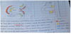
What are the processes of transportation?

A
  • Traction - large load is pushed or rolled along the bed
  • Saltation - small pebbles/load is bounced along the bed
  • Suspension - fine silt/ alluvium is carried in the flow making the river look brown
  • Solution - chemicals are carried invisibly in the flow.
25
Q

What are the factors affecting the rate of transportation?

A

There will be more transported when there’s high volume and velocity.

26
Q

What is deposition?

A

Dropping or dumping

27
Q

What is the hydrological cycle?

A

The continuous transfer of water from the oceans into the atmosphere, then onto the land and finally back into the oceans. it has a fixed amount of water.

28
Q

What is evaporation?

A

Liquid to gas (water to water vapour)

29
Q

What is transpiration?

A

Evaporation of water from plants

30
Q

What is evapotranspiration?

A

Both evaporation and transpiration happening together

31
Q

What is condensation?

A

Gas to liquid (water vapour to water)

32
Q

What is precipitation?

A

Any form of water falling onto the earth’s surface

33
Q

What is infiltration?

A

Water soaking into soil

34
Q

What is percolation?

A

Water moving vertically down through soil and rock

35
Q

What is throughflow?

A

Water in soil flows down

36
Q

What is groundwater flow?

A

Moisture in rock travelling through pores and cracks of rocks towards the sea

37
Q

What is surface run-off?

A

Water flows overground downhill

38
Q

What is interception?

A

Water lands on leaves and doesn’t hit ground

39
Q

What is saturation?

A

When the water can no longer infiltrate the soil. Holes and cracks are full of water.

40
Q

What is unsaturated?

A

Pores and cracks contain air and water

41
Q

What is groundwater?

A

Moisture held in the rocks

42
Q

What is the mouth?

A

Where the river ends at the sea or a lake.

43
Q

What does a riverbasin system have?

A

Inputs, flows (transfers), stores and outputs

44
Q

What is the start?

A

Where the river begins

45
Q

What is the river bed?

A

Bottom of the river channel

46
Q

What is the river bank?

A

The sides of the river channel

47
Q

What is load?

A

Material carried by the river

48
Q

What is alluvium/silt?

A

the river mud deposited in floods

49
Q

What is a flood plain?

A

Flat land on either side of a channe that would be covered in water if the river overflows.

50
Q

What is a river basin/drainage basin?

A

The area drained by a river and its tributaries

51
Q

What is a watershed?

A

The boundary of the river basin

52
Q

What is the upper course?

A

The section of river near the source

53
Q

What is the lower course?

A

The section of river near the mouth

54
Q

What is the middle course?

A

The section of river between the upper and lower courses

55
Q

What is a meander?

A

A bend in the channel

56
Q

What is a cross-section/cross-profile?

A

A slice through

57
Q

What is a long profile/section?

A

The journey form source to mouth

58
Q

What is the equation for finding the cross sectional area?

A

cross sectional area (m2) = width (m) x mean depth (m)

59
Q

What is the equation for discharge?

A

Discharge (m3/s (cumecs)) = cross sectional area x mean velocity

60
Q

What is weathering?

A

The gradual break down of rocks

61
Q

Describe a V-shaped valley?

A

Steep slopes meeting at the channel with no flood plain found in the upper course.

62
Q

How is a V-shaped valley formed?

A
  1. Vertical erosion due to gravitational potential energy in upper course, by hydraulic action (power of water), abrasion (sandpapering) and corrosion (dissolving)
  2. Weathering weakens the valley sides especially by freeze thaw
  3. Slope transport - by rockfall or landslide, blocks channel. River builds up behind and erodes the natural dam, leaving a V shape. Eventually vegetation will grow and hold the valley sides in place.
63
Q

Describe interlocking spurs?

A

Finger of higher land jutting into the river’s course around which it must wind.

64
Q

Why are interlocking spurs formed?

A

Due to hard rock, vertical erosion dominant so ends of spurs not eroded

65
Q

What is a waterfall?

A

A sudden drop in the river channel/bed

66
Q

What is a plunge pool?

A

An overdeepened part of the bed under the waterfall

67
Q

What is a gorge?

A

Near vertical sided valley as wide and tall as the waterfall was

68
Q

How is the waterfall High Force formed?

A
  1. Whinstone is a more resistant rock so not easily eroded but sandstone is less resistant so eroded by hydraulic action, abrasion and corrosion
  2. Creating a plunge pool
  3. Undercutting of less resistant rocks leaves cap rock with no support
  4. Cap rock collapses so waterfall retreats upstream elaving a gorge. The broken cap rock will erode the punge pool by abrasion.
69
Q

How are rivers shown in the upper course, middle course and lower course?

A

Upper course: contour lines are close together

Middle course: doesn’t cross many contours. Meters above sea level are lower. Gentler valley sides and bendy river.

Lower course: very low meters above sea level

70
Q

Describe a river beach?

A

An area of loose material found on the inside of a meander. Also called a point bar.

71
Q

Describe a river cliff?

A

A near vertical bank on the outside bend of a meander. From a few centimetres to a few metres tall.

72
Q

Draw a cross section of a meander and explain it?

A

Outside fastest because water thrown to outside, therefore erosion by hydraulic action and abrasion undercutting river cliff causing it to collapse. This part is deep because there is no friction so the water is fast.

Inside is shallow therefore friction with bed load. The flow is slower as there’s more friction and deposition of load transported by suspension or saltation or traction.

Point bar/beach builds up on slip-off slope

73
Q

Describe an ox-bow lake?

A

A horse shoe shaped body of still water cut off from the river channel, found in the middle course.

74
Q

How does the weather, the nature of the basin, land use and river management affect the shape of a flood hydrograph?

A
  • When rainfall is heavy and lasts a long time there will be a lot of surface run off. Water will reach the river very quickly. lag time will be short and the discharge high. Rain will not be able to sink into frozen ground in winter. This also means water will flow away over the surface. (But if it is a long winter with temperatures below freezing for several weeks, snow will be held in drifts so the water levels won’t rise - this is different when there’s precipitation)
  • An impermeable rock is one which does not let water pass through. A river basin with impermeable rock will have a lot of surface run-off. A permeable rock allows water to pass through it. A river basin with permeable rock will have little surface run-off.
  • If the land is covered in trees, rainwater will be delayed in reaching the river. Where the land has been built upon, rainwater will reach the river very quickly.
  • If a dam is built across a river, flood water can be held back. This will increase lag time and reduce the peak discharge. Water can be released when river levels are lower.
75
Q

With the aid of diagrams explain the formation of an ox-bow lake.

A

Swan-neck meanders eventually turn into ox-bow lakes by fast flow causing the outside bend to erode through hydraulic action and abrasion and the slower flow on the inside bends cause deposition. These processes continue and the neck of the land becomes narrower. Eventually, the two outside bends become closer and usually, in times of flooding, the small neck of land will be broken through due to the higher discharge causing a faster flow so a higher rate of erosion. This creates a straight river channel. Over a period of time, the alluvium would deposit due to the increased friction causing the river to run out of energy and no longer carry the load and soon seals off the old meander forming an ox-bow lake. Eventually, this will dry up due to evaporation or infiltration and will leave a meander scar.

76
Q

What is discharge?

A

The volume of water passing a certain point in a river in a given time

77
Q

Give four ways that water from a rainstorm gets into a river

A
  • throughflow - water in soil travelling downhill
  • ground flow - moisture in rocj travelling through pores towards sea
  • surface run-off - water flowing overground downhill
  • direct precipitation
78
Q

What kind of river is more likely to flood (be a flashy river)?

A

Rivers with a short lag time and a high peak discharge

79
Q

What is a flood?

A

A flood is caused when the discharge exceeds channel capacity so the water overflows onto the flood plain.

80
Q

What does a river in flood mean?

A

The discharge is greater than base flow but is less than channel’s capacity.

81
Q

How can a flood be caused after a summer thunderstorm?

A

During the hot temperatures in the summer, the ground becomes impermeable therefore the large amounts of precipitation caused by the thunderstorm will not be able to infiltrate, therefore there will be no percolation, groundwater flow or through flow. This means that the large amounts of water will go into the river channel through the fastest way - surface run-off. As most of the water reaches the channel with a greater velocity, this causes the discharge levels in the channel to exceed the capacity and cause the water to overflow onto the flood plain at a rapid rate and cause a flash flood.

82
Q

What can floods be caused by?

A
  • After a summer thunderstorm
  • Deforestation
  • Urbanisation
  • Impermeable underlying rock
  • Long period of rainfall
  • Heavy snowfall following a few days when temperatures are below freezing
83
Q

How can a flood be caused by deforestation?

A

Deforestation of trees can reduce interception through leaves delaying surface run-off. Similarly, roots store soil moisture delaying water reaching the channel through through flow. The roots also take up water to use in photosynthesis therefore reduce the amount of water reaching the channel. Leaves also use the water through evapotranspiration therefore the amount of water reaching is reduced. If the number of trees is reduced, there’ll be more water at a greater velocity reaching the channel through surface run-off which means that a greater amount of water will reach the river in a given time, causing the water to overflow onto the flood plain.

84
Q

How can flood be caused by urbanisation?

A

Tarmac and concrete surfaces are used when building urban areas and these are impermeable. This means that the water will not infiltrate, resulting into no percolation, groundwater flow or through flow. This means that the majority of water reaches the channel through surface run-off at a greater velocity due to large amounts of water reaching the channel at the same time. The efficient drains and gutters which are smooth and cylinder-shaped remove surface water. Small streams are forced to travel through these and this causes a smaller amount of friction causing a reduced amount of water touching the wetted perimeter causing the discharge of a river to rise rapidly and increase the channel’s capacity causing the water to overflow onto the floodplain. (Also deforestation)

85
Q

Describe the differences in hydrographs for an urban area and a wooded rural area.

A
  • Urban area has a shorter lag time
  • Urban area has a higher peak discharge
  • Urban area has a steeper rising and falling limb/more flashy
86
Q

What are the inputs, stores, flows and outputs of a hydrological cycle?

A
87
Q

Annotate a picture of a gorge.

A
88
Q

How is a floodplain formed?

A
  1. A river floods due to high discharge in the river channel which is hard to cope with. The water then overflows and fills the valley and transports the load by suspension, saltation and larger load by traction. The load is then deposited as alluvium on the sides of the channel as the river no longer has the energy to carry the load due to the shallow water and increased friction. Eventually the water infiltrates or evaporates.
  2. As time passes after millions of years, many floods occur causing layers of deposition to build up and get compressed to soon form a flood plain.

A floodplain is also built up by deposition on the inside bend of the meander, on the slip-off slope as shallower water has friction with the bed load it slows down and runs out of energy.

89
Q

Give another feature of deposition.

A

Levées

90
Q

Describe a levée.

A

A cheese wedge-shaped ridge along the bank of a river. They can also be man-made.

91
Q

How is a levée formed?

A
  1. The river floods due to higher discharge to what the river channel could cope with. As it flows it transports its load by traction, saltation and suspension. Soon as it leaves the channel it loses energy due to shallow water therefore large load such as gravel is deposited first and then the medium sized such as sand. The fine sediments of alluvium are carried right across the plain.
  2. Repeated flooding creates ridges as large load is deposited over other large loads in the same place.
  3. During times of low discharge the river can’t even transport alluvium so it’s depositted on the bed. It builds up so much causing the river to flow above the flood plain.
  4. By having the river above the flood plain, there’s a great flood risk so levées are strengthened with concrete or made taller or an artificial levée may be built - set back on the flood plain to stop the flood water from spreading too far.
92
Q

What is a flood hydrograph?

A

A visual representation to show how the discharge of a river changes over time (line graph). In response to a rainfall event (bar graph).

93
Q

What is base flow?

A

Discgarge if water at normal times through ground water

94
Q

What is rising limb?

A

The section of the graph which shows the rapid increase of discharge in river due to surface run-off.

95
Q

What is falling limb?

A

The section of the graph which shows the gradual movement of precipitation reaching the river in decreasing amounts due to through flow.

96
Q

What is peak discharge?

A

The highest volume of water passing a point in a given time in the river channel.

97
Q

What is peak rainfall?

A

The highest amount of precipitation

98
Q

What is lag time?

A

The numer of hours taken to reach the maximum level of discharge in the river since the highest amount of rainfall

99
Q

What is a flashy river?

A

A river with a steep rising and falling limb and a high peak discharge therefore a shorter lag time

100
Q

What is the case study for flooding in the rich world?

A

Teukesbury, Gloucestershire, 2007

101
Q

What were the causes for the Tewkesbury flood?

A
  1. Dry spring - soil moisture evaporated so ground hard, no infiltration possible. This caused fast surface run-off and increased discharge. River Severn overflowed.
  2. Heavy rainfall in May and June - this saturated the soil and therefore no more infiltration took place. In July, there was excessive rain - equivalent of 2 months’ rain fell in one day.
102
Q

What were the long term and short term effects of the flooding of Tewkesbury?

A

Short Term

  1. Roads were cut off such as the M5 due to concrete being an impermeable surface therefore no infiltration and a lot of surface run-off causing water to be absorbed by car engines causing break-downs. This resulted in many accidents and arguments between drivers creating a social problem.
  2. Fields were cut off as soil became saturated therefore no more infiltration. Therefore crops were destroyed and farmers lost their money. Animals also had to suffer due to a loss of vegetation. Also, the Cathedral was left on a dry island so it was unreachable.
  3. Due to contamination of water treatment works and pumping de to overflow of water, tap water was cut off to avoid diseases such as cholera. This meant that people had to find and collect water themselves which was time consuming. This was a problem for the elderly as they couldn’t have walked if water was at a distance.

Long Term

  1. Floods destroyed homes leaving many homeless therefore people had to live in caravans leading to a life without freedom for almost a year and hence resulting in depression. Possessions were also lost and food supplies were wiped out inside homes so people had to be in hunger for a while.
  2. Insurance premiums increased by three or four times as too many houses became flooded so many weren’t able to afford to help retrieve back their homes and had to stay in their caravans.
  3. Suspension in river caused alluvium in water to deposit onto fields benefitting farmers as this would result into fertile (full of nutrients) soil, this would have helped them retrieve back their lost crops and vegetation.
103
Q

What were the long term and short term responses of the flooding of Tewkesbury?

A

Short Term

  1. Tanks were brought by large lorries to provide drinking water and so were bottled water which people used to fill buckets and bottles with as water services have stopped to avoid contaminated water due to the overflow of water and therefore water borne diseases such as cholera.
  2. Community spirit was developed as people helped neighbours if basic amenities became destroyed by giving them temporary places to live such as places in their homes. This would have also helped some come out of depression as they have a place to live for a while.
  3. The RAF rescued people from cars from the M5 such as the elderly and pregnant ladies as they were stuck there due to car engines absorbing the water and breaking down.
  4. Some vandalised tanks with paint or washing up liquid to prevent people from collecting drinking water leaving many thirsty and without water to do their daily chores. The elderly would have had to walk further to find clean water and this would have been a problem if they were living alone.

Long Term

  1. Many were signed to the free flood warning scheme to reduce further damage and better flood defences which would possibly make future floods less serious and this gave hope for the people who were depressed and upset.
  2. Several suffered from depression due to a loss of precious items and no permanent place to live as houses have been destroyed by surface run-off of flood water.
  3. Family life and relationships were damaged as young children had no freedom when they’re in caravans and some family members may be separated as they’re stuck somewhere else due to transport breaking down. This will result in a lot of worry for the families.
104
Q

How can an area with impermeable underlying rock cause flooding?

A

This will increase the risk of a flood because the precipitation is unable to infiltrate the soil. Therefore, resulting in more surface run-off, rather than ground water flow or through flow which are much slower processes than surface run-off. This means that the water will flow downhill much quicker resulting in the channel exceeding its capacity.

105
Q

How can a long period of rainfall cause flooding?

A

Heavy precipitation will increase the surface run-off coming into the river as the rain is falling so fast that the ground becomes saturated very quickly and no more water can infiltrate. The surface run-off gets to the river quickly all in one go causing the discharge of the river to be high and the water level to rise until it overflows its banks as the discharhe is higher than the base flow.

106
Q

How can a heavy snowfall following a few days when temperatures are below freezing cause flooding?

A

There is a high flood risk when a heavy snowfall follows a few days when temperatures remained below freezing because when the snow melts, it is unable to infiltrate as the ground is impermeable due to frozen soil. As there is no infiltration, there’s no through flow so all the water travels by fast surface run-off to the channel creating increased discharge which causes a flood.

107
Q

What is the case study for flooding in the poor world?

A

River Ganges, Bangladesh, 2004

108
Q

What were the short term and long term effects of the Bangladesh floods?

A

Short Term

  • The flooding of the River Ganges resulted in 600 deaths across Bangladesh. Disease continued to raise the death toll after increased rainfall. Because of raw sewage and mud entering the drinking water system, more died in Dhaka due to diarrhoea.
  • There was destruction of many buildings and bridges and roads and railways being submerged by flood water therefore transport became near impossible. Not only the locals suffered but this also prevented international aid as the Dhaka Airport was flooded.
  • Vegetable crops were destroyed including Bangladesh’s main food supply paddy firelds. Home food supplies were also washed away leaving people in a desperate situation.

Long Term

  • Many schools and hospitals in Dhaka were damaged. This costed a lot to repair and the government did not have enough money as it’s an LEDC. Damaged schools reduced the chance of people coming out of poverty and resulted in low literacy rates. There were many casualties in the hospitals so there were orpaned children and families without support decreasing the chance of escaping poverty.
  • Paddy rice was washed away and is the main crop leaving people in hunger. Some cash crops such as jute and sugar were washed away leaving country with little exports and large deficit.
  • Silt was left behind making soil fertile which increased yield of paddy rice and helped country recover from food and grow exports.
109
Q

What were the short term and long term responses of the Bangladesh floods?

A

Short Term

  • The local community could do very little as they had very little money so continued daily lives such as cycling rickshaws for rich. Some tried to find high relief away from flood but were unsuccessful due to low relief and had to carry animals and possessions. Others tried to rebuild temporary homes and rescue people with small, self-owned boats.
  • There was heavy reliance on emergency aid from international organisations such as the United Nations, wealthy governments and charities. These provided food supplies as the the country’s main food supply consisted of rice paddies which had been washed away, medicine, clothing and blankets. Charities such as WaterAid supplied water purification tablets and posters highlighting risks.

Long Term

  • An action plan for flood control was prepared by the World Bank to build embankments and dams and levées. These prevented water from reaching the land but due to inadequate funding and corruption this scheme remains unfinished.
  • The World Bank installed flood forecasting and early warning schemes so that during future floods homes and villages could be prepared in advance therefore preventing further flood damage.
  • Food shelters were built on higher land on stilts with emergency supplies such as dried food and clean water so that people could stay there temporarily with their cattle and access uncontaminated supplies.

(Last two responses are cheaper and more appropriate for farming and fishing communities in rural areas)

110
Q

What is hard engineering?

A

Building man-made structures to control the river and stop flooding

111
Q

What is soft engineering?

A

Working with the river system to reduce the effects of flooding

112
Q

Describe what needs to be done with dams and reservoirs in hard engineering.

A

Dams and reservoirs - build concrete wall across valley in upper course to create a reservoir. Control discharge released to prevent flooding downstream.

113
Q

What are the costs and benefits of dams and reservoirs?

A

Costs

  • Very expensive to construct and maintain dam
  • Flooded farm land and any settlements under reservoir

Benefits

  • Controlled discharge so no future flooding downstream
  • Dam can produce hydro electric power
  • Lake provides new habitats and water offers sports opportunities.
114
Q

Describe what needs to be done in warn and prepare in soft engineering.

A

Warn and prepare - environment agency records precipitation and uses past research on hydrographs to predict peak discharge and lag time. Warnings on TV, radio, text messages and websites to local residents. Residents move valuables and furniture upstairs. Council give out sand bags.

115
Q

Describe what has to be done in river straightening in hard engineering.

A

River straightening - with concrete bank channel and high levées. Cut off meanders and provide new strong channel that won’t be eroded and can cope with high discharge. Increased gradient so water leaves area faster.

116
Q

What are the costs and benefits of river straightening?

A

Costs

  • Expensive to build new land and keep dredging
  • Loss of habitats on river banks - animals can’t burrow into concrete
  • Reduced lag time lower down river - flooding

Benefits

  • Reduces flooding in urban area
  • Straight river helps shipping - faster
  • River taken up less space than meandering course
117
Q

Describe what needs to be done for do nothing in soft engineering.

A

Do nothing - let river flood when discharge exceeds channel capacity

118
Q

What are the costs and benefits of do nothing?

A

Costs

  • Costs of repairing flood damage

Benefits

  • Alluvium improves quality of soil on flood plain
  • No building costs
  • Improves habitats in wetlands
119
Q

What are the costs and benefits of warn and prepare?

A

Costs

  • Long term research costs
  • Time and effort of everybody moving belongings
  • Cost of repairs to buildings
  • Everybody might not be able to respond - not home, on their own

Benefits

  • Reduces costs of damage
  • Cheap to warn people
  • Individuals are responsible, government don’t pay, so taxes stay low
120
Q

Describe what needs to be done for flood plain zoning in soft engineering?

A

Flood plain zoning - allow differnet land uses in different areas

121
Q

What are the costs and benefits of flood plain zoning?

A

Costs

  • Frequent flooding of farmland so farmer loses income
  • Towns already built at wet point site so expensive to move them

Benefits

  • Minimal damage to housing
  • Improved soil due to new alluvium, once floodwater has evaporated or infiltrated
122
Q

Describe what needs to be done for afforestation?

A

Plant trees in upper course to intercept heaviest precipitation so lower peak discharge and longer lag time

123
Q

What are the costs and benefits of afforestation?

A

Costs

  • Planting and caring for saplings costs money
  • Clean up costs because flooding not reduced for 20 years
  • Cost of land for forestry
124
Q

What conclusion can be drawn about hard engineering and soft engineering?

A

Hard engineering used to be the most popular but now a combination of hard and soft is used.

125
Q

What’s the case study for hard and soft engineering?

A

River Tees

126
Q

What has been done in the River Tees?

A

Hard engineering has been done:

  • Dam - Cow Green Reservoir
  • Straightened channel by cutting off meanders
  • Flood walls and gates at Yarm with extra high banks to keep flood water out
  • Barrage - temporary dam across river that lets river water out, but no sea water can come in
127
Q

What is meant by water stress?

A

This occurs when the amount of water available does not meet that required. This may be due to an inadequate supply at a particular time or it may relate to water quality.

Demand exceeds supply

128
Q

What is meant by areas of deficit?

A

Locations where the rain that falls does not provide enough water on a permanent basis. Shortages may occur under certain conditions, e.g. long periods without rain

129
Q

What is meant by areas of surplus?

A

Areas that have more water than is needed - often such areas receive a high rainfall total, but have relatively small population.

130
Q

Why are we using more water now?

A
  • Higher population in UK so a higher demand for water.
  • Electricity power stations use water to provide electricity such as hydro stations using water from the river and fossil fuel power stations using the water as steam to turn turbines. As there are more appliances requiring electricity, more electricity is being used.
  • Houses contain many appliances which require a lot of water so this means that each household uses a high amount of water resulting in a high demand. Also, a more affluent lifestyle demands for more water as wealthy people buy more labour saving devices such as washing machines replacing hand washing. They also demand foodstuffs which are out of season and require irrigation which farmers also use.
  • Industries use large amounts of water in the processing and manufacturing of goods. large metal products such as cars require large amounts of water for cooling.
131
Q

What is the difference in water supply between the North and West, and the South and East?

A

North and West

  • High precipitation (relief) due to prevailing winds from SW and mountains
  • Good locations for reservoirs, V shaped valleys, low quality farm land, sparsely populated
  • Cooler temperatures due to high altitude and cloudy skies so less evaporation

South and East

  • Low precipitation due to rain shadow effect - clouds descend, warm and evaporate
  • Flat land, wide floodplains, already urbanised, few locations for reservoirs
  • Warmer temperatures, cloudless skies, so more evaporation
132
Q

What is the difference between the demand from the North and West and the South and East?

A

North and West

  • Few people/ low population density
  • Farmers don’t need to irrigate as high precipitation and hill, sheep/ pastoral farm
  • Few factories to use water
  • HEP stations recycle the water

South and East

  • High population density in nucleated settlements
  • Farmers irrigate as precipitation is low and arable crops use more water (greenhouses or field irrigation)
  • Many factories on flatter land, heavy mechanised use lots of water
  • Thermal and nuclear power stations use a lot of water
133
Q

Overall what is supply and demand like for both parts of the UK?

A

North and West

High supply + low demand = surplus

South and East

Low supply + high demand = deficit

134
Q

What are the solutions to deficit problems?

A
  1. Reduce demand
    • Domestic
      • Hose pipe ban
      • Water efficient machines eg. washing machines
      • Meter for water use
      • Low energy appliances and lights
    • Water companies
      • Fines if they don’t mend leaks
    • Industry
      • Meters so pay for what they use
  2. Increase supply
    • Homes have water butts to trap and store precipitation
    • Transfer water from North and West
      • By tanker or lorry - not effective as too expensive and causes environmental damage
      • Pipes - expensive to set up and maintain
      • Combination of pipe and river transfer - pipe line from the River Severn to the River Thames is cheaper to build as it’s a short pipe BUT the Severn water has different temperatures, acidity and nutrients so will kill the River Thames’ ecosystem. River Severn’s lower discharge with affect salmon migration
135
Q

What is the case study for sustainable water management .ie. dams and reservoirs?

A

Kielder Dam - North East England

136
Q

How does the Kielder Dam work?

A

The Kielder water stores precipitation from the Pennines and releases water which travels down the River Tyne to Newcastle. Some of the river’s discharge is sent down a tunnel and is transferred by river to Sanderland and Middlesborough (East). If required water can be piped from the River Tees to York.

137
Q

Why was Kielder’s location chosen?

A
  1. Relief - wide valley, steep valley sides to create deep lake, less evaporation
  2. Climate - high precipitation in Pennines causes surface run-off to fill reservoir
  3. Rock type - impermeable rocks so no percolation
  4. Population - dispersed farming settlements, low population density so few families to relocate
  5. Land quality - poor so farmers making little money
  6. Ecosystems - rough grazing and woodlands - not special so no animals extinct
138
Q

What are the costs of Kielder?

A
  • Economic:
    • cost of building dam and pipeline/tunnel and maintaining
    • compensation and relocation of a few farm families
    • buy land - but low quality so cheap
  • Social:
    • farmers forced out of family home - could have been there for generations
  • Environmental:
    • flooded land may drown animals but not many are special
139
Q

What are the benefits of Kielder?

A
  • Economic
    • farmers got compensation
    • industry can have supply of water
    • jobs in tourism, water industry and forestry
  • Social
    • choice of jobs for locals
    • improved quality of life due to leaisure activities on/around reservoir
  • Environment
    • reservoir creates more variety in habitats
140
Q

What conclusion can be drawn from Kielder?

A

Benefits outway the costs due to smaller problems in costs and larger benefits

141
Q

Why is Kielder sustainable?

A
  • As it has Pennines’ precipitation
  • No hosepipe bans even during drought for Eastern cities
  • River Tees habitat not destroyed as water from same source area
142
Q

What do you have to write about when a question asks about a description of locations of flood events?

A
  • Where mostly occurred - why
  • Difference between recent and old
  • Number of rivers affected
  • Names of rivers
  • Shape
  • Distribution
  • Use scale - how further apart and size of clusters
143
Q

How do you draw a cross section?

A
  1. Mark the point x or the point asked on a piece of paper and write how many (m) above sea level
  2. Do for other contours until finishing point
  3. Mark on line graph - axis musn’t be exaggerated a lot and labelled - if stretched tell examiner how much it it and say why you’ve done it - can see change in slope
  4. Labels asked should then be labelled